Hara, Nagano
Hara
原村 | |
|---|---|
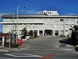
 Hara Village Hall | |
 Location of Hara in Nagano Prefecture | |
| Coordinates: 35°57′51.8″N 138°13′2.6″E / 35.964389°N 138.217389°E | |
| Country | Japan |
| Region | Chūbu (Kōshin'etsu) |
| Prefecture | Nagano |
| District | Suwa |
| Area | |
| • Total | 43.26 km2 (16.70 sq mi) |
| Population (February 2019) | |
| • Total | 7,661 |
| • Density | 180/km2 (460/sq mi) |
| Time zone | UTC+9 (Japan Standard Time) |
| Phone number | 0266-79-2100 |
| Address | 6549-1 Hara-mura, Suwa-gun, Nagano-ken 391-0100 |
| Climate | Dfa |
| Website | Official website |

Hara (原村, Hara-mura) is a village located in Nagano Prefecture, Japan. As of 1 February 2019[update], the village had an estimated population of 7,661 in 2445 households,[1] and a population density of 174 persons per km2. The total area of the village is 43.26 square kilometres (16.70 sq mi).
Geography
[edit]Hara is located in eastern Nagano Prefecture. The village is located in a mountainous area, and includes Mount Yatsugatake partly within its borders.
Surrounding municipalities
[edit]Climate
[edit]The village has a humid continental climate characterized by warm and humid summers, and cold winters with heavy snowfall (Köppen climate classification Dfa). The average annual temperature in Hara is 9.5 °C (49.1 °F). The average annual rainfall is 1,271.5 mm (50.06 in) with September as the wettest month. The temperatures are highest on average in August, at around 22.0 °C (71.6 °F), and lowest in January, at around −3.0 °C (26.6 °F).[2]
| Climate data for Hara (1991−2020 normals, extremes 1978−present) | |||||||||||||
|---|---|---|---|---|---|---|---|---|---|---|---|---|---|
| Month | Jan | Feb | Mar | Apr | May | Jun | Jul | Aug | Sep | Oct | Nov | Dec | Year |
| Record high °C (°F) | 14.3 (57.7) |
17.1 (62.8) |
22.2 (72.0) |
27.4 (81.3) |
30.1 (86.2) |
31.2 (88.2) |
33.7 (92.7) |
33.9 (93.0) |
31.9 (89.4) |
26.7 (80.1) |
22.2 (72.0) |
18.3 (64.9) |
33.9 (93.0) |
| Mean daily maximum °C (°F) | 2.4 (36.3) |
3.6 (38.5) |
8.3 (46.9) |
15.1 (59.2) |
20.2 (68.4) |
23.1 (73.6) |
26.8 (80.2) |
28.1 (82.6) |
23.4 (74.1) |
17.4 (63.3) |
11.7 (53.1) |
5.6 (42.1) |
15.5 (59.9) |
| Daily mean °C (°F) | −3.0 (26.6) |
−2.2 (28.0) |
1.9 (35.4) |
8.0 (46.4) |
13.5 (56.3) |
17.3 (63.1) |
21.3 (70.3) |
22.0 (71.6) |
17.7 (63.9) |
11.5 (52.7) |
5.5 (41.9) |
0.0 (32.0) |
9.5 (49.0) |
| Mean daily minimum °C (°F) | −8.1 (17.4) |
−7.8 (18.0) |
−3.8 (25.2) |
1.7 (35.1) |
7.5 (45.5) |
12.7 (54.9) |
17.1 (62.8) |
17.6 (63.7) |
13.5 (56.3) |
6.8 (44.2) |
0.3 (32.5) |
−4.9 (23.2) |
4.4 (39.9) |
| Record low °C (°F) | −16.9 (1.6) |
−19.7 (−3.5) |
−14.5 (5.9) |
−8.7 (16.3) |
−2.5 (27.5) |
2.4 (36.3) |
9.5 (49.1) |
9.4 (48.9) |
1.2 (34.2) |
−4.7 (23.5) |
−10.5 (13.1) |
−15.1 (4.8) |
−19.7 (−3.5) |
| Average precipitation mm (inches) | 46.6 (1.83) |
57.5 (2.26) |
100.3 (3.95) |
100.4 (3.95) |
110.6 (4.35) |
151.1 (5.95) |
167.9 (6.61) |
112.9 (4.44) |
168.7 (6.64) |
143.6 (5.65) |
68.9 (2.71) |
43.1 (1.70) |
1,271.5 (50.06) |
| Average precipitation days (≥ 1.0 mm) | 6.2 | 6.1 | 9.7 | 9.7 | 10.3 | 12.7 | 13.7 | 10.0 | 10.7 | 9.3 | 7.4 | 6.1 | 111.9 |
| Mean monthly sunshine hours | 185.2 | 183.3 | 190.2 | 197.2 | 211.9 | 164.9 | 172.9 | 204.5 | 156.3 | 165.0 | 177.7 | 179.1 | 2,188.4 |
| Source: Japan Meteorological Agency[3][2] | |||||||||||||
History
[edit]The area of present-day Hara was part of ancient Shinano Province. The present village of Hara was established on April 1, 1889 by the establishment of the modern municipalities system.
Demographics
[edit]Per Japanese census data,[4] the population of Hara has grown slightly over the past 50 years.
| Year | Pop. | ±% |
|---|---|---|
| 1940 | 5,913 | — |
| 1950 | 7,269 | +22.9% |
| 1960 | 6,521 | −10.3% |
| 1970 | 5,869 | −10.0% |
| 1980 | 6,125 | +4.4% |
| 1990 | 6,502 | +6.2% |
| 2000 | 7,207 | +10.8% |
| 2010 | 7,575 | +5.1% |
| 2020 | 7,680 | +1.4% |
Economy
[edit]The economy of Hara is based on agriculture.
Education
[edit]Hara has one public elementary school and one public junior high school operated by the village government. The village does not have a high school.
Transportation
[edit]Railway
[edit]- The village has no passenger railway service.
Highway
[edit]International relations
[edit]Local attraction
[edit]- Akyū ruins, a National Historic Site
- Yatsugatake Museum of Art
Notable people from Hara
[edit]- Risa Itō, manga artist
References
[edit]- ^ Hara Village official statistics(in Japanese)
- ^ a b 気象庁 / 平年値(年・月ごとの値). JMA. Retrieved April 20, 2022.
- ^ 観測史上1~10位の値(年間を通じての値). JMA. Retrieved April 20, 2022.
- ^ Hara population statistics
- ^ "International Exchange". List of Affiliation Partners within Prefectures. Council of Local Authorities for International Relations (CLAIR). Archived from the original on 2 January 2017. Retrieved 21 November 2015.
External links
[edit] Media related to Hara, Nagano at Wikimedia Commons
- Official Website (in Japanese)


