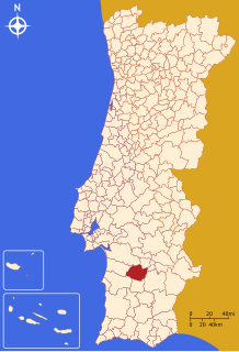
Ferreira do Alentejo
Appearance
Ferreira do Alentejo | |
|---|---|
 | |
 | |
| Coordinates: 38°03′N 8°06′W / 38.050°N 8.100°W | |
| Country | |
| Region | Alentejo |
| Intermunic. comm. | Baixo Alentejo |
| District | Beja |
| Parishes | 4 |
| Government | |
| • President | Aníbal Costa (PS) |
| Area | |
| • Total | 648.25 km2 (250.29 sq mi) |
| Population (2011) | |
| • Total | 8,255 |
| • Density | 13/km2 (33/sq mi) |
| Time zone | UTC+00:00 (WET) |
| • Summer (DST) | UTC+01:00 (WEST) |
| Local holiday | March 5 |
| Website | www |
Ferreira do Alentejo (European Portuguese pronunciation: [fɨˈʁɐjɾɐ ðu ɐlẽˈtɛʒu] ), or simply Ferreira, is a town and a municipality in Beja District in Portugal. The population in 2011 was 8,255,[1] in an area of 648.25 km2.[2]
The human activity in the municipality dates back to antiquity, with evidence of prehistoric and Roman settlement. The village was later part of the Order of Santiago da Espada, having its first charter passed on 5 March 1516 by King Manuel I.
The present Mayor is Aníbal Coelho Costa, elected by the Socialist Party. The municipal holiday is March 5.
Parishes
[edit]Administratively, the municipality is divided into 4 civil parishes (freguesias):[3]
References
[edit]- ^ Instituto Nacional de Estatística
- ^ "Áreas das freguesias, concelhos, distritos e país". Archived from the original on 2018-11-05. Retrieved 2018-11-05.
- ^ Diário da República. "Law nr. 11-A/2013, page 552 49" (pdf) (in Portuguese). Retrieved 22 July 2014.
External links
[edit]- Town Hall official website Archived 2015-08-11 at the Wayback Machine
- Photos from Ferreira do Alentejo
- Some more Photos from Ferreira do Alentejo
- Ferreira do Alentejo Geocoin


